
EERI Washington Presents: EERI 2020 Distinguished Lecture, featuring David Bonowitz – September 16, 2020, Noon-1pm
September 16, 2020
Noon-1pm
RSVP at EERI.Washington@gmail.com to receive a the teams link for this webinar.

EERI Washington is pleased to welcome David Bonowitz for a presentation of the 2020 Distinguished Lecture. RSVP for this virtual event by emailing EERI.Washington@gmail.com.
David Bonowitz (M.EERI,1994), a leading structural engineer practicing in San Francisco, will deliver the 2020 Distinguished Lecture, “Functional Recovery: What it Means to Design for Community Resilience,” in this webinar. David’s lecture will focus on the emerging concept of functional recovery as a basis for earthquake-resistant design. Designing buildings and infrastructure for limited downtime – or an acceptably quick functional recovery – is not new, but it is receiving new attention through state and federal legislation, and showing new feasibility through research and technology. Most intriguing is the recognition that designing for functional recovery is a necessary tool for achieving community-wide earthquake resilience. And if progress is to be measured at the community level, functional recovery will also be a matter of public policy. The lecture will look at the roles EERI members can play in shaping this thinking into design practice with four sets of questions: definitional, technical, policy, and implementation.
EERI Washington Chapter Meeting: October 17th
EERI 2019 Distinguished Lecture
Featuring
Ross W. Boulanger, PhD, PE, NAE
Professor, Director of CGM
University of California, Davis
Monday, September 9, 2019
5:30 PM Reception (Drinks and appetizers will be served)
6:00 PM EERI WA Board Welcome – News
6:10 PM EERI Distinguished Lecture
University of Washington
Electrical and Computer Engineering Building 105 (ECE 105)
185 Stevens Way
Seattle, WA 98195-2500
FREE Admission – RSVP HERE
Liquefaction: Lessons, Challenges, and Opportunities
Liquefaction during earthquakes has been the subject of extensive study for over half a century and is now routinely addressed in engineering practice using a wide range of technical approaches that depend on the project size and importance. These past studies have produced major advances in our scientific understanding of liquefaction phenomena and the engineering practices used to address liquefaction hazards, but there remain numerous situations where knowledge gaps and engineering practice limitations hinder the efficient mitigation of earthquake-induced liquefaction damages to our infrastructure and communities. This presentation examines a number of lessons, challenges, and opportunities regarding the evaluation and mitigation of liquefaction hazards, including aspects of site characterization, engineering analysis methods, challenging soil types, remediation methods, performance-based engineering procedures, and risk management approaches.
Ross W. Boulanger, PhD, PE, NAE
Professor, Department of Civil and Environmental Engineering
Director, Center for Geotechnical Modeling
University of California, Davis
Ross W. Boulanger is the Director of the Center for Geotechnical Modeling and professor in the Department of Civil and Environmental Engineering at the University of California, Davis. He received his Ph.D. and M.S. degrees in Civil Engineering from the University of California at Berkeley in 1990 and 1987, respectively, and his B.A.Sc. degree in Civil Engineering from the University of British Columbia in 1986. He became a registered professional engineer in the State of California in 1992.
Ross’ research and professional practice are primarily related to liquefaction and its remediation, seismic soil-pile-structure interaction, and seismic performance of dams and levees. His research over the past 25 years has produced over 200 publications, including co-authoring with I. M. Idriss the EERI Monograph MNO-12 on Soil Liquefaction during Earthquakes. He has served as a technical specialist on seismic remediation and dam safety projects for private, state, and federal organizations. His honors include the TK Hsieh Award from the Institution of Civil Engineers, and the Ralph B. Peck Award, Norman Medal, Walter L. Huber Civil Engineering Research Prize, and Arthur Casagrande Professional Development Award from the American Society of Civil Engineers (ASCE).
Ross’ professional service includes being a member of the Board of Directors for the United States Society on Dams (USSD) from 2009-2015, member of the Earthquake Engineering and Soil Dynamics Committee of ASCE since 1996 (chair from 2004-2009), vice-chair of the Technical Committee on Earthquake Geotechnical Engineering of the International Society of Soil Mechanics and Geotechnical Engineering (ISSMGE) since 2009, co-leader with Nick Sitar on the Geotechnical Extreme Events Reconnaissance (GEER) team for the 2011 Tohoku earthquake in Japan, and member of the Research Committee for the Pacific Earthquake Engineering Research (PEER) Center from 2003-2010.
FREE Admission – RSVP HERE
EERI Washington Chapter Meeting: September 9th
CO-SPONSORED BY THE ASCE GEO-INSTITUTE EARTHQUAKE ENGINEERING AND SOIL DYNAMICS TECHNICAL COMMITTEE SPEAKERS BUREAU
Featuring
Dr. Ben Mason
Associate Professor, Oregon State University
Monday, September 9, 2019
5:30 PM Reception (Drinks and appetizers will be served)
6:15 PM EERI WA Board Welcome
6:30 PM Lecture
Seattle Public Library
Washington Mutual Foundation Meeting Room
1000 Fourth Ave.
Seattle, WA 98104-1109
FREE Admission – RSVP HERE
| Flowslides Initiated by the 28 September 2018 MW7.5 Palu-Donggala Earthquake |

| The MW7.5 Palu-Donggala earthquake occurred on 28 September 2018 in Sulawesi, Indonesia. The strike-slip earthquake rupture occurred on the Palu-Koro fault, which runs north-south through Central Sulawesi. The Palu-Donggala earthquake triggered a series of large landslides (or flowslides) throughout the Palu Basin. In general, the large flowslides initiated beneath moderate slopes (i.e., grades between 2 to 6 percent) and significant liquefaction, as evidenced by numerous sand boils, occurred within the flowslides’ footprints. Given the large footprints of the flowslides as well as the population density of the Palu Basin, the flowslides claimed lives, destroyed hundreds of houses, and left a heavily-used irrigation canal inoperable. A National Science Foundation funded Geotechnical Extreme Events Reconnaissance (GEER) team traveled to Palu to conduct post-earthquake field reconnaissance from 11 November to 17 November 2018. We documented the geologic setting, collected perishable field data, and obtained eyewitness accounts to understand the mechanisms responsible for initiation and progression of the large flowslides. To assist the post-earthquake reconnaissance, we performed high-resolution mapping using a DJI Inspire 2 unmanned aerial vehicle (UAV, or “drone”) mated with a Zenmuse X4S camera (1-inch sensor, with 20 MP resolution). We used Pix4D mapper to process the ground-controlled unmanned aerial vehicle photographs, and we developed high-resolution orthomosaic images and digital elevation models. Within this talk, I will report the findings of our post-earthquake reconnaissance efforts and propose hypothesized mechanisms responsible for flowslide initiation and progression. Our interpretations are aided by cone penetration tests performed after our initial reconnaissance effort. |

Ben Mason, Ph.D.
Associate Professor, College of Engineering
Oregon State University
Ben’s primary field of research interest is natural hazards engineering. Within this broad field, he has interests in geotechnical earthquake engineering, including soil-structure interaction and residual soil liquefaction as well as coastal geotechnical engineering, including fluid-soil-structure interaction, momentary soil liquefaction, and tsunami-induced scour. He has a particular interest in how a combined earthquake and tsunami event affects coastal soil instability and ultimately the stability of coastal buildings and infrastructure. He uses physical modeling techniques coupled with numerical and analytical modeling to investigate his aforementioned research interests. He is also interested in the fields of sustainable geotechnical engineering and geotechnical engineering education. He participates in post-earthquake reconnaissance events to motivate and strengthen his research and teaching interests.
Lawrence Berkeley Nat’l Lab: New Sensor Could Shake Up Earthquake Response Efforts
After the most recent series of earthquakes in Southern California, Lawrence Berkeley National Labs has put out a news release describing their recent work (in conjunction with University of Nevada-Reno) developing optical sensor technology that can be used to speed up the time needed to evaluate the post-earthquake damage to buildings, and assess whether they are safe enough to enter or require red-tagging.
For more information, the full article can be found on the Lawrence Berkeley National Lab website.

Credit: Diana Swantek/Berkeley Lab
Report Available: Funding for URM Retrofits in Seattle
The National Development Council has provided their final report to the City of Seattle on URM retrofit funding. With the completion of this report, along with the recommendations of the URM Policy Committee, the City will begin developing high-level policy recommendations to the Mayor’s Office for their review later this year.
The report is available on the Seattle Department of Construction and Inpections’ Unreinforced Masonry Buildings website.
The city continues to be interested in hearing your thoughts on this issue. You can contact the URM Policy Committee at: SCI_URM_Policy_Committee_Comments@seattle.gov
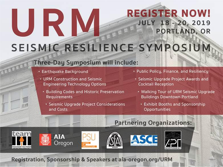
AIA Oregon: URM Seismic Resilience Symposium
EERI Washington Chapter members may be interested in attending The American Institute of Architects Oregon Chapter’s URM Seismic Resilience Symposium. Event details are included below:
URM Seismic Resilience Symposium
July 18-20, 2019
Unreinforced Masonry (URM) buildings present a challenge for earthquake-prone communities. There are over 1,650 URM buildings in Portland and millions around the world. These structures are important historic, architectural, cultural, and economic landmarks, but their vulnerability to earthquakes imperils them and the people that live and work in them.
The URM Seismic Resilience Symposium, July 18-20, 2019, is a three-day event for architects, engineers, owners, property managers, and anyone that might deal with URM buildings. AIA HSW and Engineering continuing education credits will be available.
Visit the AIA Oregon website for details on the agenda, speakers, and special events.
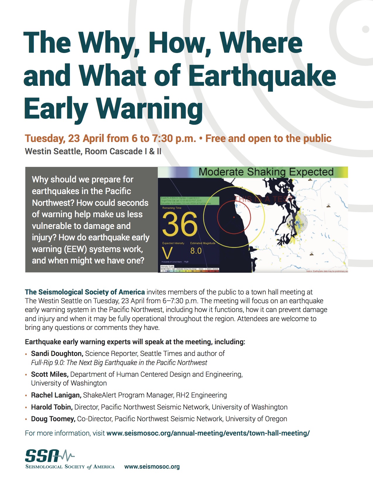
The Why, How, Where and What of Earthquake Early Warning – A Seismological Society of America Town Hall
The Seismological Society of America will be hosting a town hall meeting on earthquake early warning systems in the Pacific Northwest as part of their 2019 Annual Meeting in Seattle. This event is free to attend!
For more information, please visit the Seismological Society of America Website
Mon, April 1st: The William B. Joyner Lecture Featuring Dr. Ellen Rathje, University of Texas at Austin
|
|||||||||||||
|
|||||||||||||
|


 Ellen M. Rathje is the Warren S. Bellows Centennial Professor in the Department of Civil, Architectural, and Environmental Engineerin
This Monday: Friedman Family Visiting Professionals Program Lecture with Jay Wilson and EERI at UW
